***Updated at 5 p.m. to include information from the Central Pacific Hurricane Center and the National Hurricane Center’s 5 p.m. updates.***
As of the 5 p.m. CPHC update, Ignacio has held maximum sustained winds near 90 mph with higher gusts. Additional strengthening is possible over the next day or so, followed by a weakening trend expected to begin Sunday.
The system is moving northwest at 8 mph.
Hurricane force winds extend 25 miles from the center, tropical storm force winds extend 80 miles from the center.
A Hurricane watch could be issued as early as this evening or tomorrow morning.
Jimena is moving toward the west near 12 mph, and this motion is expected to continue for the next 12 to 24 hours. A turn toward the west-northwest is expected by late Saturday.
ARTICLE CONTINUES BELOW AD
ARTICLE CONTINUES BELOW AD
Maximum sustained winds have rapidly increased to near 125 mph with higher gusts. Jimena is a category 3 hurricane on the Saffir-Simpson Hurricane Wind Scale. Additional strengthening is forecast during the next 24 hours, and Jimena is expected to be near category 5 strength on Saturday. After that time, fluctuations in intensity are possible, but Jimena should remain a powerful hurricane.
Hurricane force winds extend outward up to 30 miles from the center and tropical storm force winds extend outward up to 105 miles.
***Updated at 11 a.m. to include information from the Central Pacific Hurricane Center and the National Hurricane Center’s 11 a.m. updates.***
By: Jamilia Epping
Hurricane Ignacio was located about 785 miles east-southeast of Hilo and has slightly slowed down since the Central Pacific Hurricane Center’s 5 a.m. update. The storm is moving in a northwest direction at 8 miles per hour and is expected to continue in its motion over the weekend.
ARTICLE CONTINUES BELOW AD
Maximum sustained winds associated with Hurrican Ignacio remain at 90 mph. Forecasters say the potential for increased strength remains throughout Friday and into the weekend.
Hurricane Jimena continues to follow its earlier path, as of 11 a.m. The storm was 1,135 miles southwest of Baja, Calif., moving at a rate of 12 mph in a west direction.
The National Hurricane Center has reported an increase in wind speed by 15 mph since 5 a.m. to maximum sustained winds of 105 mph. Jimena’s increase was within the realm of what was forecasted by the NHC as the environment remains conducive to continued strengthening.
Hurricane Jimena is still expected to peak as a major hurricane later Friday.
***Original story posted at 7:41 a.m.***
ARTICLE CONTINUES BELOW AD
By: Jamilia Epping
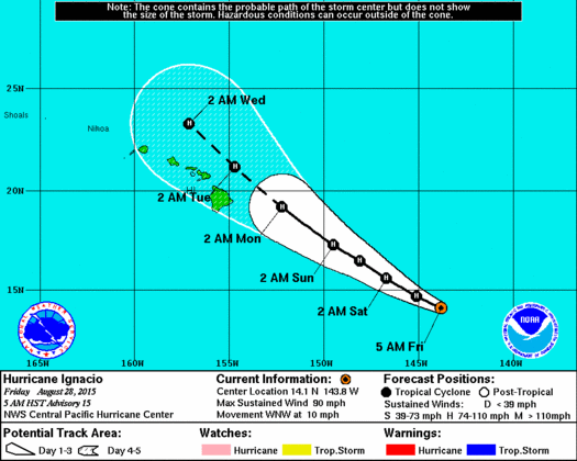
As of the Central Pacific Hurricane Center’s 5 a.m. advisory bulletin, Hurricane Ignacio was 840 miles east-southeast of Hilo, traveling at 10 miles per hour in a west-northwest direction that is expected to continue before taking a slight northwest turn.
Central Pacific Hurricane Center image, as of 5 a.m.
Forecasts predict that the forward movement will decrease through Sunday.
Hurricane Ignacio is holding maximum sustained winds of 90 mph with the expectation that it will continue to strengthen through late Saturday before beginning to weaken. The intial strengthening will be helped by a friendly environment, according to CPHC, who says low shear is a contributing factor.
CPHC officials say that the center of Hurricane Ignacio should pass close by, but to the northeast of the Big Island as a hurricane early next week.
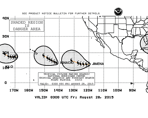
National Hurricane Center image, as of 5 a.m.
Recently-formed Hurricane Jimena continues to quickly intensify, according to the National Hurricane Center.
As of 5 a.m., the storm was about 1,073 miles southwest of the southern tip of Baja, Calif., traveling west at about 12 mph.
Hurricane Jimena was hosting maximum sustained winds of 90 mph as it rapidly intensifies.
Over the next 48 hours, NHC forecasters are predicting that Hurricane Jimena will strengthen. An environment of low shear and warm water are conditions expected throughout the forecast period that are conducive to strengthening.
Hurricane Jimena is still south of a strong ridge that extends southwest from the southwestern United States, which will keep it on a western course over the next day. After a 24-hour period, the ridge is forecast to weaken and Hurricane Jimena will then be allowed to turn west-northwest through day five.
This comments section is a public community forum for the purpose of free expression. Although Big Island Now encourages respectful communication only, some content may be considered offensive. Please view at your own discretion. View Comments