***Updated at 11 p.m. to include information from the National Hurricane Center’s 11 p.m. advisory.***
By: Jamilia Epping
Hurricane Ignacio has increased in power since the National Hurricane Center’s 5 p.m. update.
As of 11 p.m., Ignacio was 1,205 miles east-southeast of Hilo with an increase of maximum sustained winds listed at 85 mph.
The storm is moving in a west-northwest direction at 13 mph, with forecasts predicting Ignacio to continue on its path throughout the forecast period due to a strong subtropical ridge to the north of the storm that is producing a deep layer of east-southeast steering flow.
Forecasters predict that Hurricane Ignacio will continue to strengthen over the next 48 hours as light to moderate eastern shear, warm water, and a moist atmosphere remains.
ARTICLE CONTINUES BELOW AD
ARTICLE CONTINUES BELOW AD
As of 11 p.m., NHC has named Tropical Storm Jimena, formerly known as Thirteen-E, It is the tenth tropical storm of the season.
National Hurricane Center image of Tropical Storm Jimena, as of 11 p.m.
The storm is currently 845 miles south-southwest of the southern tip of Baja, Calif. and is moving west-northwest at 15 miles per hour, a slight decrease from earlier in the day.
Maximum sustained winds associated with Jimena are at 40 mph.
Forecasts expect a turn toward the west with some decrease in forward speed through Thursday and the movement is expected to last through Friday.
NHC officials say that the maximum sustained winds associated with the storm are expected to continue to increase, reaching hurricane strength on Friday.
ARTICLE CONTINUES BELOW AD
***Updated at 5 p.m. to include updated information from the National Hurricane Center’s 5 p.m. advisory.***
By: Jamilia Epping
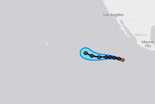
Iganacio has reached hurricane status, according to the National Hurricane Center’s 5 p.m. advisory.
National Hurricane Center image of Hurricane Ignacio as of 5 p.m.
With wind speeds up to 75 miles per hour, Hurricane Ignacio has become the seventh hurricane of the 2015 Eastern North Pacific Season.
Hurricane Ignacio is currently 1,275 miles east-southeast of Hilo, moving in a west-northwest direction at 13 miles per hour. Forecasts predict that the storm will continue in its present movement through Friday.
ARTICLE CONTINUES BELOW AD
Environmental conditions are expected to remain favorable for strengthening.
National Hurricane Center image of Tropical Depression Thirteen-E, as of 5 p.m.
The forecast for Tropical Depression Thirteen-E has not seen any drastic changes since the 11 a.m. advisory. NHC officials say that the depression may form into a tropical storm on Thursday.
As of 5 p.m., the storm was still near Mexico, about 840 miles from Baja, Calif., moving in a west-northwest direction at a slightly slower pace at 17 miles per hour. Maximum sustained winds zre at 35 mph.
***Original story posted at 11:51 a.m.***
By: Jamilia Epping
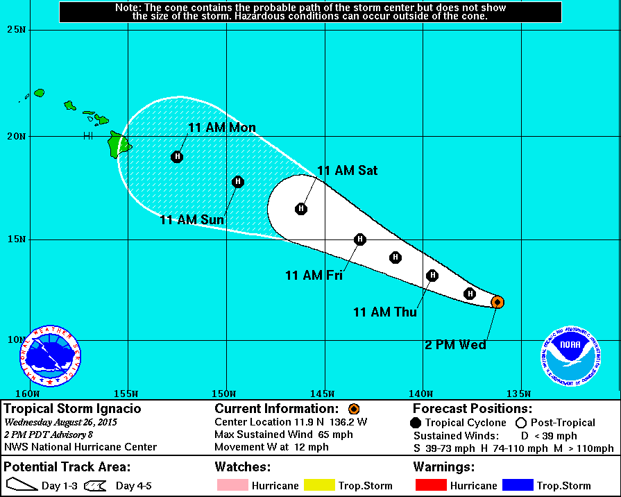
Tropical Storm Ignacio continues to strengthen as it inches closer to Hawai’i. As of the National Hurricen Center’s 11 a.m. advisory, the storm was located about 1,365 miles east-southeast of Hilo, traveling west at about 12 mile per hour.
National Hurricane Center image of Tropical Storm Ignacio as of 11 a.m.
NHC says Ignacio’s current movement is expected to continue through Wednesday night and take a west-northwest turn on Thursday as it is steers around the subtropical ridge.
The storm’s maximum sustained winds have increased to 65 mph, and strengthening is forecast to continue over the next 48 hours. Ignacio is expected to become a hurricane on Thursday.
Light to moderate shear and warm waters over the next handful of days are predicted to be contributing factors to the favorable strengthening conditions.
NHC forecasters report that weakening is expected in the long range due to an increase in shear and less favorable thermodynamic conditions.
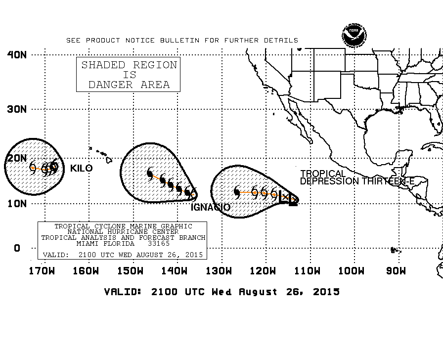
Along with the monitoring of Tropical Storm Ignacio, NHC is currently watching newly formed Tropical Depession Thirteen-E in the Eastern Pacific. As of 11 a.m., Thirteen-E was located west of Mexico, a decent distance from Hawai’i.
National Hurricane Center image of Tropical Depression Thirteen-E, as of 11 a.m.
Thirteen-E was traveling west at about 20 mph with maximum sustained winds of 30 mph.
NHC forecasters say that the environment ahead of the storm is characterized by low shear, very warm waters, and a moist atmosphere. These conditions make strengthening likely throughout the forecast period. Official forecasts note that with steady intensification, the storm could reach major hurricane strength by day five.
Currently, Thirteen-E is located south of a strong mid-level ridge over northern Mexico and the adjacent Pacific waters. The ridge should steer the storm west through day five and potentially begin to turn west-northwest by the end of the forecast period.
This comments section is a public community forum for the purpose of free expression. Although Big Island Now encourages respectful communication only, some content may be considered offensive. Please view at your own discretion. View Comments