***Updated at 5 p.m. to include new National Weather Service information.***
By: Jamilia Epping
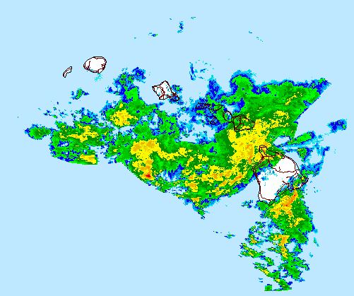
A Flood Advisory issued for the Big Island has been extended through 7:45 p.m.
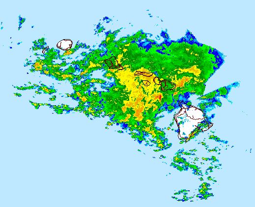
The National Weather Service reports that just before 5 p.m., radar showed moderate to heavy rain over the western and northern portions of the Big Island. Moderate to heavy rain continues to the west of the Big Island and is moving towards the east.
NWS notes that although rain has become light over most of Ka’u, Puna and South Hilo, ponding water and overflowing streams can make driving difficult.
***Updated 2:10 p.m. to include information from the National Weather Service. ***
ARTICLE CONTINUES BELOW AD
ARTICLE CONTINUES BELOW AD
By: Jamilia Epping
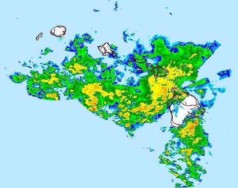
The National Weather Service has issued a Flood Advisory for the Big Island until 5 p.m.
National Weather Service image, as of 2:15 p.m.
Moderate to heavy rainfall is falling in areas across the island southeast of a line from Laupahoehoe to Kona Airport.
NWS reports that rain rates were about an inch per hour near Hawaiian Acres in Puna and over the South Kona slopes.
Areas included in the advisory include Hilo, Kea’au, Pahoa, Pahala, Naalehu, Kainaliu, Kealakekua, and Honaunau.
ARTICLE CONTINUES BELOW AD
A Flash Flood Watch for the entire state remains in effect through Tuesday at 6 p.m.
***Updated at 12:10 p.m. to include updated National Weather Service information.***
By: Jamilia Epping
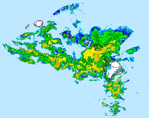
National Weather Service image, as of 11:25 a.m.
A Flash Flood Watch for the State of Hawai’i has been extended through Tuesday at 6 p.m. The National Weather Service reports that unstable and moist air mass remains over the state. The tropical moisure is interacting with island terrain and is expected to produce localized, intense, and slow moving heavy rain that may bring the potential for flash flooding.
The Flood Advisory for the Big Island has expired, however a Flash Flood Warning remains in effect until 2 p.m. Monday.
ARTICLE CONTINUES BELOW AD
***Updated at 11 a.m. to inlcude addition information from the National Weather Service.***
By: Jamilia Epping
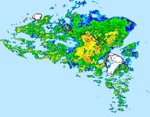
The National Weather Service has extended the Flash Flood Warning on the Big Island through 2 p.m.
National Weather Service image, as of 11:05 a.m
Radar continues to show two areas of heavy rain that will effect large portions of the Big Island. NWS reports that one of the areas will impact West Hawai’i from Kona to Upolu Point. The other area is forecast to bring rainfall to southeast slopes from Kalapana to South Point.
The areas of rain are expected to impact the entire Big Island, with the exception of the Hamakua and North Hilo districts.
A Flood Advisory remains in effect for some areas through 11:45 a.m.
***Updated at 9:50 a.m. to include new advisory information. ***
By: Jamilia Epping
A Flash Flood Warning has been issued for the Big Island UNTIL 12:30 p.m., in addition to the current Flood Advisory posted until 11:45 a.m.
National Weather Service image, as of 9:55 a.m.
The National Weather Service reports intense rainfall moving into to Kona and through Keauhou. Rainfall is expected to produce flooding along low lying roads like Ali’i Drive and other flood prone properties.
NWS says that heavy rain may also impact portions of the north and south Kohala distrcits.
Additional areas inluded in the warning are Waikoloa Village, Saddle Road Junction, Kainaliu, Kealakekua, Honaunau, Holualoa, Hawi, Kohala Mountain Road, and Highway 190 from Waimea to Kona.
***Updated at 8:40 a.m. to include additional National Weather Service information.***
By: Jamilia Epping
The National Weather Service has extended the Flood Advisory on the Big Island through 11:45 a.m.
National Weather Service image, as of 8:25 a.m.
Just before 8:30 a.m., NWS reported radar showing bands of moderate to heavy rainfall moving over the slopes of the Ka’u, Puna, and North and South Hilo districts.
Also included in the advisory is Hilo, Pahoa, Mountain View, Pahala, and Naalehu.
***Original story posted at 7:30 a.m.***
By: Jamilia Epping
A Flood Advisory that was initally issued Sunday evening has been extended for the third time, this time through 8:45 a.m.
National Weather Service image, as of 7:15 a.m.
The National Weather Service reported Monday morning that radar was showing heavy rain from near Hilo to South Point, moving in a northwest direction at 10 miles per hour.
Coastal and lower slopes of north Hilo and south Hilo, along with the Puna and Ka’u districts, are also included in the advisory.
As of 7:15 a.m. there are no road closures in effect due to the heavy rain conditions.
This comments section is a public community forum for the purpose of free expression. Although Big Island Now encourages respectful communication only, some content may be considered offensive. Please view at your own discretion. View Comments