***Updated at 5:15 p.m. to include 5 p.m. Central Pacific Hurricane Center information.***
Tropical Depression Four-E has slowed slightly, according to the latest update from the Central Pacific Hurricane Center.
As of 5 p.m., Four-E was located 685 miles east of Hilo and moving to the west-northwest at 13 miles per hour. It is maintaining maximum sustained winds of 35 mph.
The latest forecast track continues to show the storm moving well north of the Big Island and most of the state. The 5 p.m. “cone of uncertainty,” however, shows the storm taking a slight turn to the west near Kauai by early Saturday afternoon.
Forecasters still expect the storm to strengthen over the next 24 hours to tropical storm status, but weakening is predicted by Friday.
***Updated at 2:20 p.m. to include 2 p.m. Central Pacific Hurricane Center information. ***
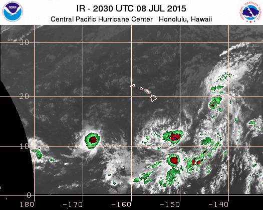
Tropical Depression Four-E has advanced about 15 miles closer to Hilo in the past three hours. The Central Pacific Hurricane Center is reporting that the storm system is about 735 miles to the east-southeast of Hilo, as of 2 p.m.
The storm continues to trek on a path to the west-northwest at a rate of about 15 miles per hour, according to the CPHC.
Weather conditions are expected to bring in some muggy weather over the weekend. Rain is expected with the storm, but strong winds shouldn’t be a major factor if the storm continues on its current path.
The CPHC notes that southernly swells have been bringing in advisory level surf Wednesday, with a high surf advisory remaining in effect for south facing shores. Surf heights will be boosted over the weekend again for south facing shores, beginning Friday.
***Updated at 11:30 a.m. to include 11 a.m. Central Pacific Hurricane Center information.***
An 11 a.m. update Tropical Weather Outlook update from the Central Pacific Hurricane Center notes that Tropical Depression Four-E is currently about 750 miles to the east of Hilo.
The storm is moving in a west-northwest direction at about 15 miles per hour. CPHC estimates that the depression will continue to move in its current direction and within its current speed over the next 48 hours.
Maximum winds within the system are between 35 mph and 55 mph. Higher gusts are intermittent.
CPHC expects that the storm will gradually strengthen over the next day, and that the tropical depression could become a tropical storm either later Wednesday or overnight into Thursday. After becoming a tropical storm, CPHC believes the storm would weaken Thursday night and Friday.
***Original story posted at 8:23 a.m. ***
The National Weather Service’s Central Pacific Hurricane Center is maintaining watch over Tropical Depression Four-E, which has relocated to about 800 miles east-southeast of Hilo, as of the center’s 8 a.m. Tropical Weather Outlook.
According to CPHC, Four-E is still carrying maximum sustained winds of 35 miles per hour and moving to the northwest at 16 mph.
While it is still difficult to predict exactly what the storm will do as it gets closer to the islands, forecasters are currently expecting the trade winds to go away by the weekend, bring extremely humid and muggy weather to the islands. Shower activity is still expected with this storm, with much of the rain pushed to the back end of the storm system, affecting weather conditions by the end of the weekend.
Two additional storms in the area also continue to be monitored. A weak surface low is currently located about 625 miles to the south-southeast of Hilo. CPHC says this system has a low chance, 10 percent, of forming into a system over the next 48 hours due to unfavorable environmental conditions.
Another storm system, described as a broad low pressure area, is about 975 miles to the southwest of Honolulu. The storm has environmental conditions that are conducive for development. CPHC officials say the system has a medium chance at 60 percent to form in the next 48 hours.
+
SWIPE LEFT OR RIGHT
Satellite image and forecast track as of 10 a.m. Wednesday. Central Pacific Hurricane Center image.
Satellite image as of 9:30 a.m. Central Pacific Hurricane Center image.
This comments section is a public community forum for the purpose of free expression. Although Big Island Now encourages respectful communication only, some content may be considered offensive. Please view at your own discretion. View Comments