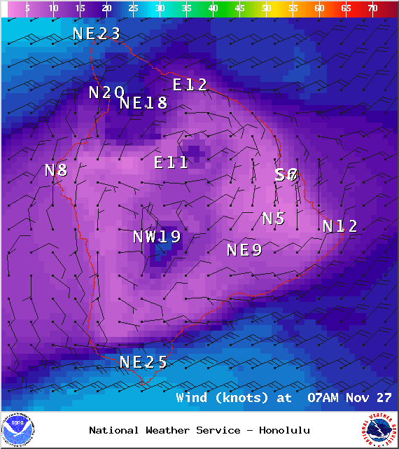
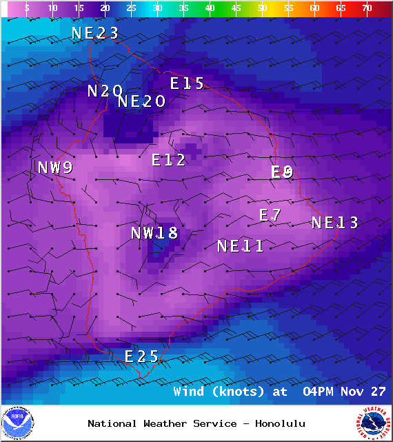
A Wind Advisory is in effect until 6 p.m. this evening for winds out of the northeast from 20 to 35 mph, gusting to 50 mph across the Kohala and Kamuela areas on the north end of the Big Island, south of Volcano along the Kau coast and near South Point. The advisory may need to be extended if strong winds persist. Winds this strong can bring down tree branches and make driving difficult, especially for high profile vehicles.
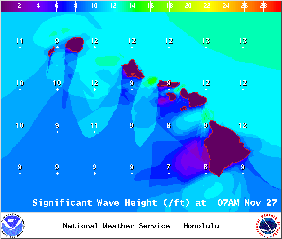
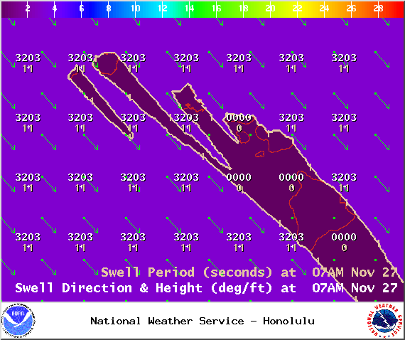
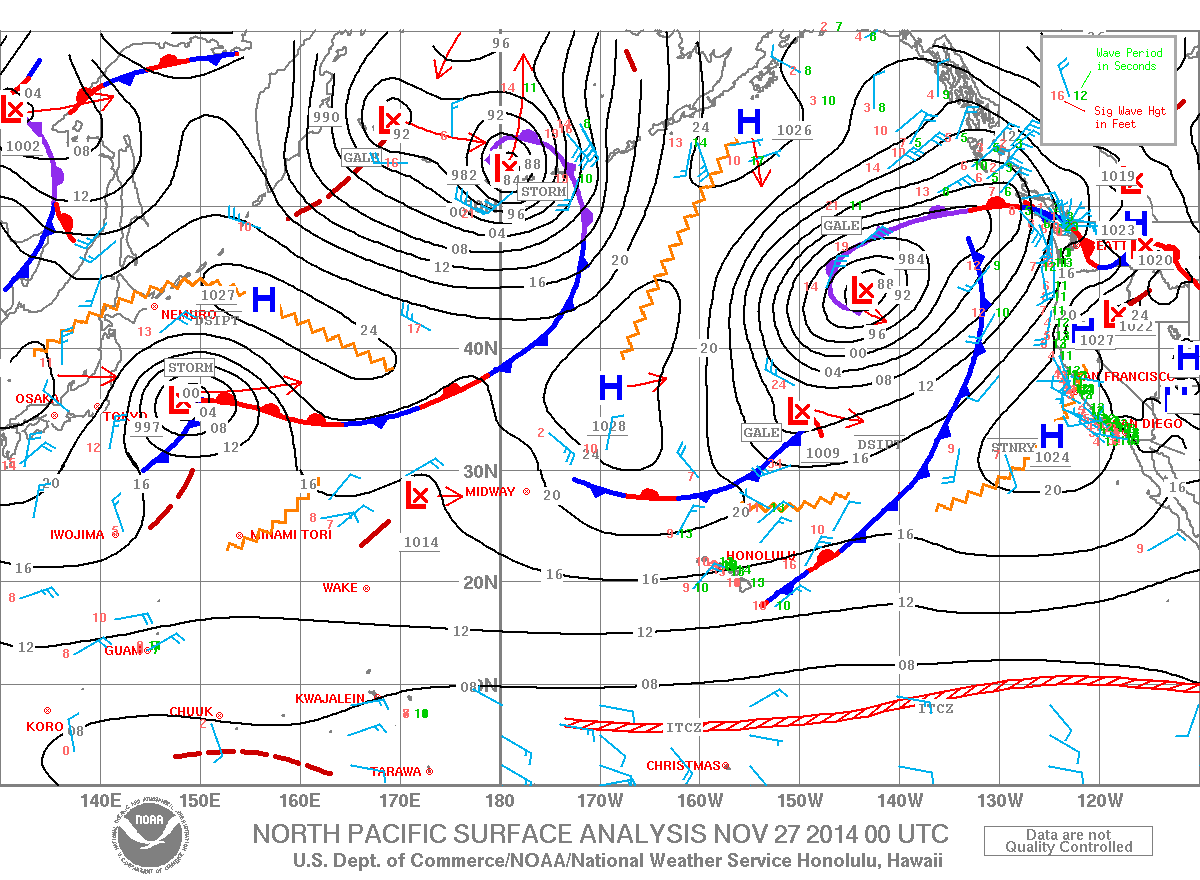
A High Surf Advisory is in effect for the north and east facing shores of the Big Island for a larger than expected north-northeast swell. Surf along north facing shores could reach heights of 12 to 15 feet. Surf along east facing shores could reach heights of 8 to 12 feet. The advisory is set to expire at 6 p.m. on Thursday.
A Marine Weather Statement has been issued by the National Weather Service for north facing harbors, including Kahului harbor. A large north-northeast swell will continue to affect these areas producing moderate surges and large breaking waves. Mariners should exercise caution when operating vessels inside harbors or near harbor entrances.
A Small Craft Advisory is posted for all Hawaii County waters until 6 p.m. today. Winds of 20 to 25 knots are expected and rough seas from 10 to 15 feet. Inexperienced mariners should avoid navigating in these conditions.
ARTICLE CONTINUES BELOW AD
ARTICLE CONTINUES BELOW AD
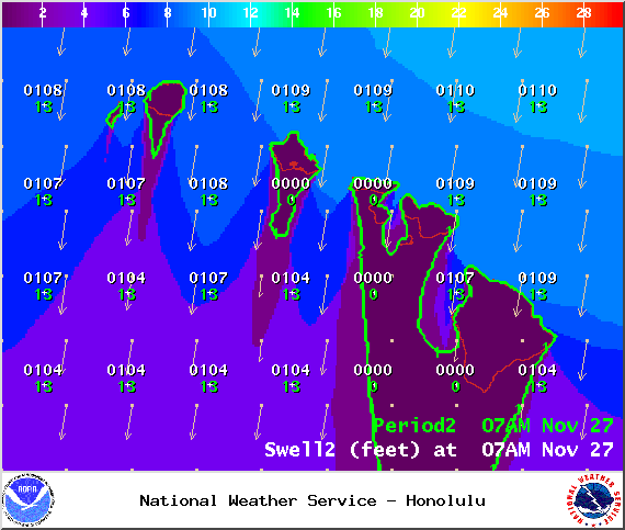
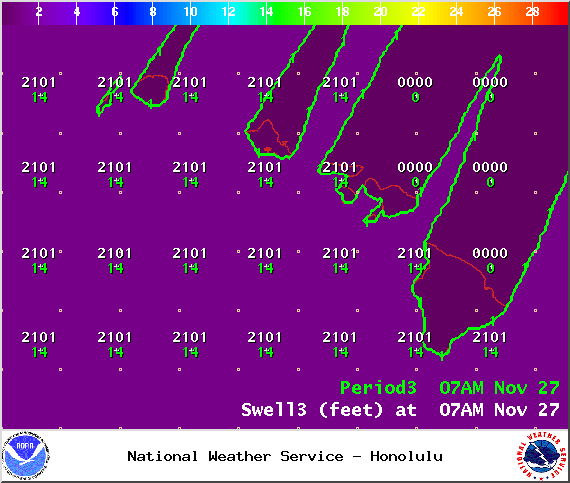
**Click directly on the images below to make them larger. Charts include: Big Island projected winds, tides, swell direction & period and expected wave heights.**
+
SWIPE LEFT OR RIGHT
Big Island Surf Forecast, Thursday November 27, 2014
ARTICLE CONTINUES BELOW AD
Hilo side: Surf is expected well overhead to double or even triple overhead at the best breaks especially early on.
Kona side: Spots that catch some of the wrap could see a slight bump in wave heights from ankle to possibly waist high. Breaks not exposed to the swell will be flat today.
South: Southeast shores open to the trade swell could see waves up to head high or more, though sloppy and choppy conditions are expected. Minimal surf out of the southern hemisphere.
Trade winds are generating swell for windward spots on the Big Island. Conditions will be choppy and sloppy.
ARTICLE CONTINUES BELOW AD
A mix of north-northwest and north-northeast swells today. This swell is expected to begin to ease as the day goes on. A new north-northwest is expected to fill in Friday bringing overhead to possibly double overhead waves at the best exposures.
Another swell out of the northeast is expected to bring another round of overhead waves over the weekend. New west-northwest swell could start building Monday with a reinforcement over the weekend. Will keep an eye on it.
Super small trace amounts of swell expected out of the SPAC. Tiny to small surf is expected off and on for top spots through Saturday this week (180-220°). There isn’t much on the horizon to get excited about.
Keep in mind, surf heights are measured on the face of the wave from trough to crest. Heights vary from beach to beach, and at the same beach, from break to break.
This comments section is a public community forum for the purpose of free expression. Although Big Island Now encourages respectful communication only, some content may be considered offensive. Please view at your own discretion. View Comments


 Big Island Surf Forecast, Thursday November 27, 2014
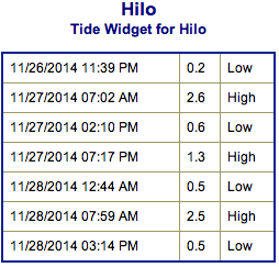 Trade winds are generating swell for windward spots on the Big Island. Conditions will be choppy and sloppy.