A HIGH SURF ADVISORY has been issued by the National Weather Service for the Big Island’s north facing shores. Surf is expected to increase to 10 + feet overnight through Wednesday morning. Therefore the advisory is posted through 6:00 am Wednesday morning and may be extended if conditions warrant that.
Expect strong breaking waves, shore break and strong longshore and rip currents making swimming difficult and dangerous.
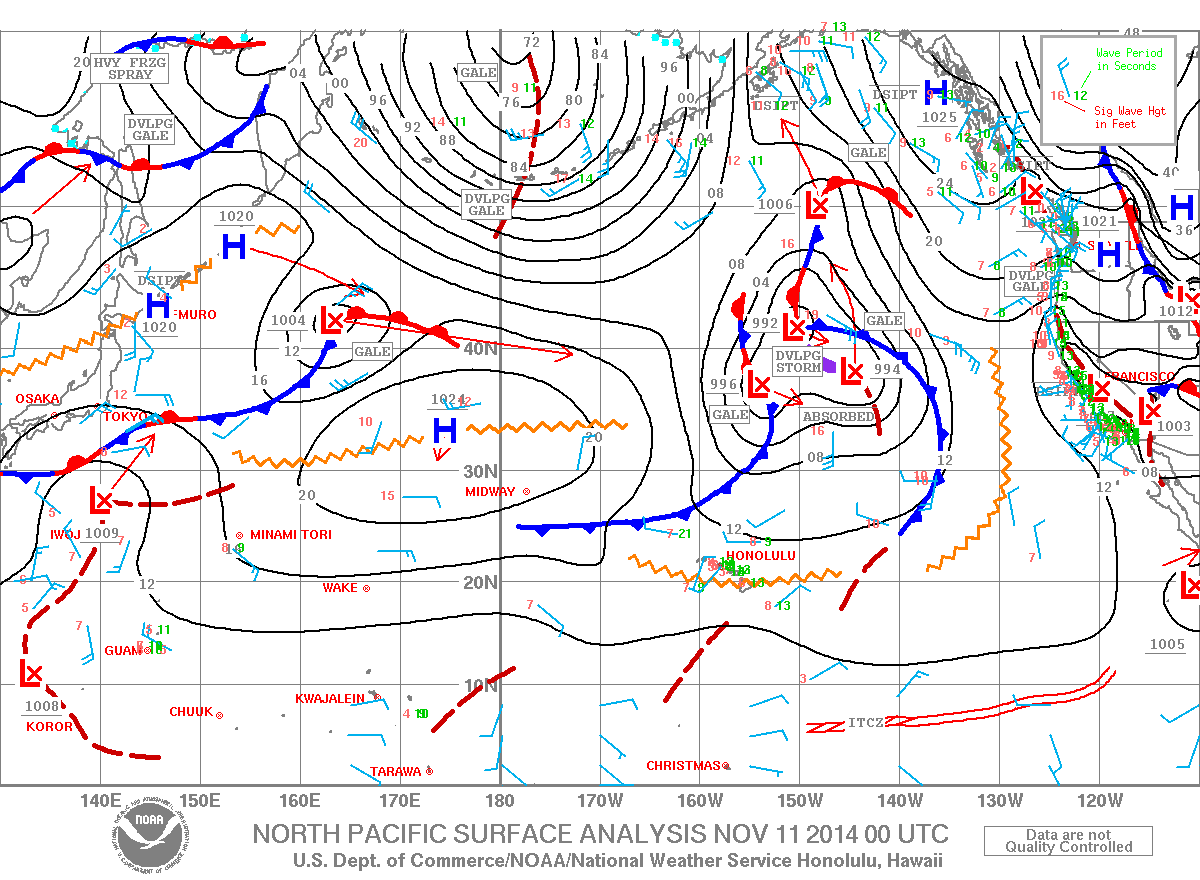
A SMALL CRAFT ADVISORY is posted for Big Island windward waters through 6:00 am Wednesday. Seas of 6 to 12 feet are expected with the largest waves expected Tuesday afternoon.
This swell we create hazardous conditions for smaller vessels. Inexperienced mariners should avoid navigating in these conditions.
**Click directly on the images below to make them larger. Charts include: Big Island high/low forecasted temperatures, projected winds, chance of cloud cover, projected localized weather conditions, vog/SO2 forecast and expected wave heights.**
+
SWIPE LEFT OR RIGHT
ARTICLE CONTINUES BELOW AD
ARTICLE CONTINUES BELOW AD
Today
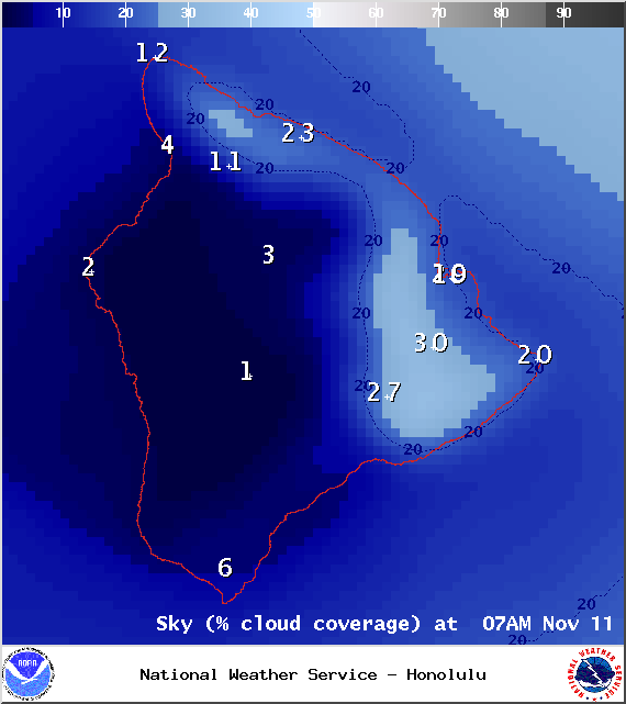
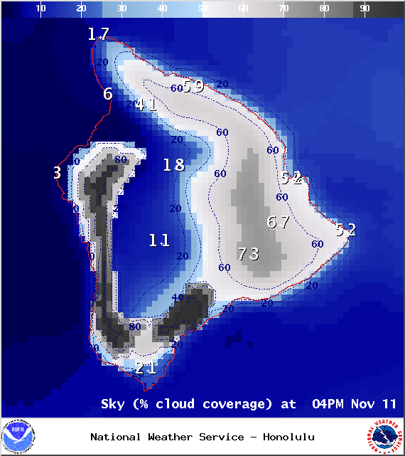
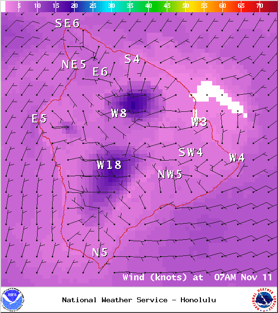
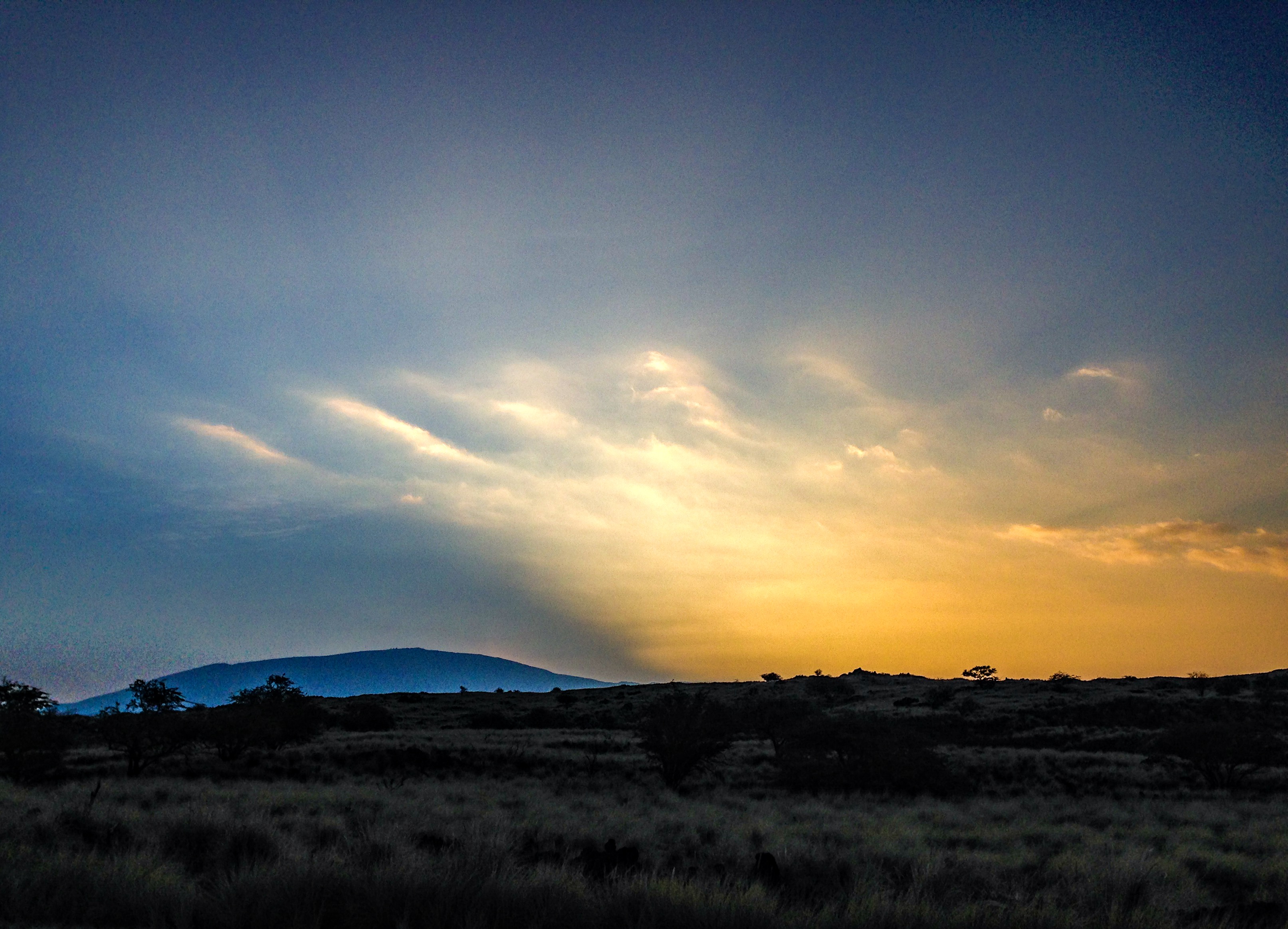
We expect hazy skies today especially in leeward spots. Partly cloudy skies are forecasted for the Big Island on this Veteran’s Day. Isolated showers are forecasted for windward and mauka areas. High temperatures should fall in the range of 81° to 86° and around 72° at 5000 feet. In general, southwest winds up to 15 mph are expected with higher winds at higher elevations.
Sunrise: 6:27 a.m.
Sunset: 5:42 p.m.
UV index at 7 (“high” exposure level)
ARTICLE CONTINUES BELOW AD
Tonight
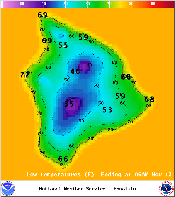
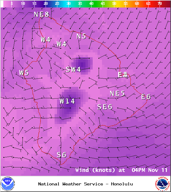
We expect partly cloudy skies tonight with scattered showers for windward and mauka areas. Leeward spots should begin to clear as the land breeze takes hold. Southwest winds are expected up to 15 mph. Low temperatures should fall in the range of 69° to 74° with a low of about 55° at 5000 feet. The moon is 80.1% full.
Moonrise: 10:14 p.m.
Moonset: 11:24 a.m.
ARTICLE CONTINUES BELOW AD
Next New Moon: Nov 22 at 2:33 a.m.
Next Full Moon: Dec 6 at 2:27 a.m.
Looking Ahead
A front that’s expected to stall over Oahu this evening is expected to help draw moisture up from the south and over the Big Island starting Wednesday. These showers will be quite disorganized and scattered in nature. A second front is expected to approach and interact with the first one reinforcing it as it moves down the island chain. The moisture from the deep tropics that is lingering in our area may be enough to fuel substantial rainfall over the weekend. Will keep an eye on it. Cooler, drier conditions are expected early next week.
Surf & Seas
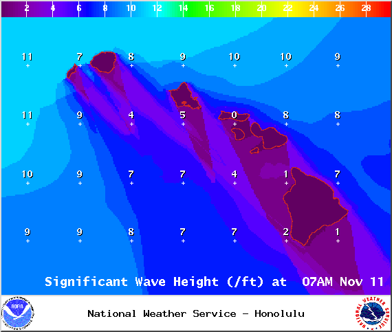
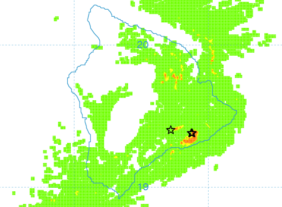
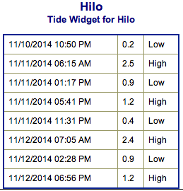
Hilo side: Surf is expected in the waist to head high range for spots best exposed to the easing north-northwest swell. A new swell will bring waves overhead to possibly double overhead to best breaks by the end of the day.
Kona side: Surf is expected to be thigh high or less. Breaks not exposed to the swells will be flat today. Spots that catch some of the north-northwest wrap could see waves waist to chest high.
South: Best breaks could see waves up to waist high for spots exposed to the trade swell along the southeast coast. South breaks that are not exposed to the trade swell should see waves thigh high or less.
Former super typhoon Nuri made history. After becoming extratropical and merging with a frontal system a couple of days ago, the storm became the strongest non-tropical storm ever recorded in the NPAC.
Though we don’t expect a giant swell, the system is expected to bring us a solid large northwest swell (310-335°) building through today and tonight, peaking on Wednesday with overhead to double overhead waves, maybe even bigger sets at the best exposures. The Kona side is shadowed from the swell and will be significantly smaller but may still catch a wrap at the best exposed breaks.
A series of northwest and north-northwest swells is expected to bring swell energy through the weekend with a couple of reinforcing swells showing up on models for early next week as well.
Small leftovers are expected to bring us waves in the thigh high or less range and gradually fade through the week. Most Kona spots will remain flat. There isn’t much on the horizon out of the South Pacific.
Keep in mind, surf heights are measured on the face of the wave from trough to crest. Heights vary from beach to beach, and at the same beach, from break to break.
Almanac for Hilo Airport
Maximum Temperature for today:
Normal 81°
Record 86° / Set in 1968 and tied in 1987 and 1990
Minimum Temperature for today:
Normal 68°
Record 63° / Set in 1969 and tied in 1993
Image: NOAA / NWS
Image: NOAA / NWS
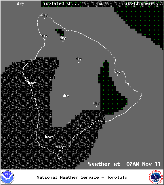
Expected weather conditions at 7am – Image: NOAA / NWS
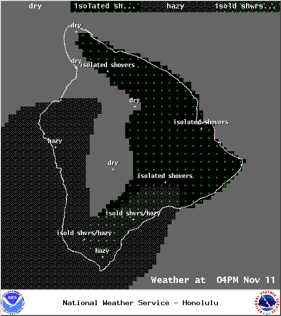
Expected weather conditions at 4pm – Image: NOAA / NWS
This comments section is a public community forum for the purpose of free expression. Although Big Island Now encourages respectful communication only, some content may be considered offensive. Please view at your own discretion. View Comments


 Surf & Seas
 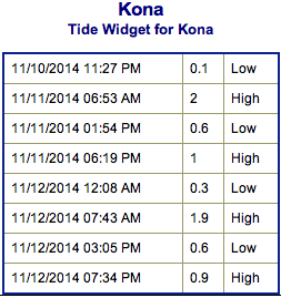 Former super typhoon Nuri made history. After becoming extratropical and merging with a frontal system a couple of days ago, the storm became the strongest non-tropical storm ever recorded in the NPAC.