8 P.M. UPDATE: Impact Update on Hurricane Ana
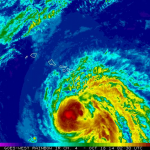
The Central Pacific Hurricane Center has just released their 8 p.m. update on Hurricane Ana. There are no changes to the forecast since the 5pm update other than the distance our islands are from the hurricane. The center of Ana is 200 miles SW of Hilo, 170 miles SSW of Kailua-Kona and 130 miles SW of South Point.
**New** Radar at 830 pm was showing the outer rainbands and thunderstorms from hurricane Ana lashing parts of the Big Island, mainly the southern parts of the Kau and Kona districts, as well as the southern and western coastal waters surrounding the Big Island. Additional heavy showers and thunderstorms are likely to continue overnight as Ana gradually moves away from the Big Island. Strong wind gusts to tropical storm force are expected in the heavier showers and storms overnight. Based on the latest forecast for Ana, the flash flood watch for the Big Island has been updated and is now in effect until noon Saturday.
Summary of Alerts
HURRICANE WARNING – Posted for all Hawaiian offshore waters starting Friday afternoon.
TROPICAL STORM WARNING – Currently in effect for all Hawaiian Offshore Waters, Big Island leeward coastal waters and Big Island southeast waters.
TROPICAL STORM WATCH – Currently up for the entire state and all coastal waters.
FLASH FLOOD WATCH – Posted for the Big Island until noon Saturday.
FLASH FLOOD ADVISORY – Posted for southeast slopes and shores, lower Kohala and north Kona slopes through 1:30am.
Current Situation
Hurricane Ana is a Category 1 storm with 80 mph maximum sustained winds, gusting to 98 mph. It is moving to the northwest at 13 mph.
Hurricane force winds extend outward 25 miles from the center of the storm, and tropical storm force winds extend 105 miles.
A decrease in forward speed is expected Saturday night and Sunday. If the track does not change, Ana is expected to pass 150 miles southwest of the Big Island tonight and 175 miles southwest of the rest of the islands over the weekend. Ana could strengthen a bit more over the next 12 hours but is expected to slowly weaken late Saturday and Sunday.
Potential impacts for the Big Island
Chance of tropical storm conditions is 7 percent for South Point, 8 percent for Kailua-Kona, 5 percent for Hilo.
Winds: Kau and South Kona may get winds from 25 to 35 mph, gusting to 50 mph tonight. Higher elevations of the Big Island could see wind numbers from 35 – 45 mph, gusting to 60 mph.
Rain: Rainfall rates of 4 to 6 inches, possibly up to a foot of rain along southeast facing slopes, are expected.
Surf: Hawai’i County Civil Defense reports surf of 10 to 15 feet is already occurring near South Point. The surf is expected to peak tonight and Saturday morning at 20 feet along the Puna & Kau coastlines during the closest approach. Elevated surf up to 12 feet is possible along the Kona coast on Saturday.
Seas: Leeward waters of the Big Island can expect 35 – 45 mph winds, gusting to 65 mph with seas up to 25 feet. Off Cape Kumukahi, winds are expected from 20 – 30 mph with seas of 15 – 20 feet.
Keep in mind, this is a large system and not a single point. Slight deviations to the right, or north, could have significant negative impacts on the effects we see to our island weather. Slight deviations to the left, or south, could similarly have a positive effect on our weather. We will continue to closely monitor the system and the impending conditions as Ana continues to approach.
**This post was updated when the intermediate advisory at 8:00pm was posted.**


