2 P.M. UPDATE: Ana Strengthens, But Forecast Remains Unchanged
The Central Pacific Hurricane Center conducted a press briefing at 2 p.m. Friday. Warning Coordination Meteorologist Chris Brenchley presented the latest information on Tropical Storm Ana, including potential impacts as the system continues to approach the state.
Below are some highlights from the briefing. including timing, forecast probability, and anticipated impacts.
Summary of Alerts
HURRICANE WARNING – Posted for all Hawaiian offshore waters, beginning Friday afternoon.
TROPICAL STORM WARNING – Currently up for all Hawaiian Offshore waters, Big Island leeward coastal waters, and Big Island southeast waters.
TROPICAL STORM WATCH – Up for the entire state and all coastal waters.
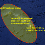
FLASH FLOOD WATCH – Currently posted for the Big Island until Sunday, but it is anticipated that it will cover the entire state beginning Friday afternoon.
Current situation
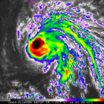
Hurricane Ana currently has maximum sustained winds at 80 mph.
Ana is moving west-northwest at 17 mph.
Hurricane force winds extend 20 miles from the center of the system. Tropical storm force winds extend 80 miles from the center.
The center of Tropical Storm Ana was last located near 16.6 N and 156.2 W, about
230 miles south-southwest of Hilo; 215 miles south of Kailua-Kona, 160 miles south-southwest of South Point; 295 miles south of Kahului, Maui; 320 miles south-southeast of Kaunakakai, Molokaʻi; 295 miles south of Lānaʻi City; and 345 miles south-southeast of Honolulu, Oʻahu.
A slight turn to the northwest is expected today and Saturday. A decrease in forward speed is expected Saturday night and Sunday. On this forecast track, the center of Ana will pass about 115 miles southwest of the Big Island tonight and about 115 miles southwest of the rest of the main Hawaiian islands this weekend. Some strengthening is expected today. The system is expected to weaken into a tropical storm by Sunday morning.
Uncertainty
The probability of tropical storm conditions continues a gradual downward trend – for Maui leeward waters it’s 34%; 8% in Hilo; 16% in Kailua-Kona, 20% near South Point, 36% in Honolulu, 40% in Lihue, and 45% for Niihau.
Potential Impacts
Over the next 6 to 12 hours, rain showers will increase on the Big Island. Hilo will see an increase in rain this afternoon while Kailua-Kona is expected to see the worst effects late this evening and into tomorrow morning. Ana’s effects will start to be seen in Maui County later tonight and into Saturday morning. Ana is expected to begin to impact Oahu Saturday evening and Sunday for Kauai.
 Heavy rain and thunderstorms are expected for the Big Island today, potentially causing dangerous flash flooding with excessive runoff and causing possible mud slides and rock slides in steep terrain. Flooding is possible statewide over the weekend. These heavy rain conditions are likely to sweep up the island chain from east to west through the weekend. For the island of Hawai’i, rainfall amounts of 6 – 8 inches are expected. Higher amounts are also possible, up to 12 inches, in the most vulnerable spots.
Large, dangerous surf conditions will impact the eastern end of the Hawaiian islands, spreading westward through the weekend as well. South and southeast shores could see wave heights in the 10 – 20 foot face range. Additional storm surge of 1 -2 feet for southeastern shores is likely. There are already reports of 15 foot waves at South Point. Surf up to 12 feet has also been reported farther up the coast.
Winds are expected to increase to 30 mph. Gusts could reach 50 mph or more as the center of Ana passes. Highest winds will be through mountainous terrain, valleys and passes. Gusts up to 40 mph have already been recorded at South Point today.


