NASA has released the first images from a new satellite scientists say will greatly improve understanding of rainfall.
The Global Precipitation Measurement Core Observatory, dubbed GPM, was launched into space last month by NASA and the Japan Aerospace Exploration Agency, also known as JAXA.
GPM is designed to expand the capabilities of the agencies’ Tropical Rainfall Measurement Mission that began operating in 1997.
By providing greater detail and expanding the study to the Earth’s poles, GPM will give scientists a better understanding of our planet’s climate, NASA said.
NASA Administrator Charles Bolden last month said the launch means the agencies “have taken another giant leap in providing the world with an unprecedented picture of our planet’s rain and snow.”
“GPM will help us better understand our ever-changing climate, improve forecasts of extreme weather events like floods, and assist decision makers around the world to better manage water resources,” Bolden said.
Earlier this month, GPM – the first spacecraft designed to detect light rain and snowfall from space — sent back images of a cyclone located approximately 1,000 miles east of Japan.
The satellite has two instruments that provided unprecedented details about the storm.
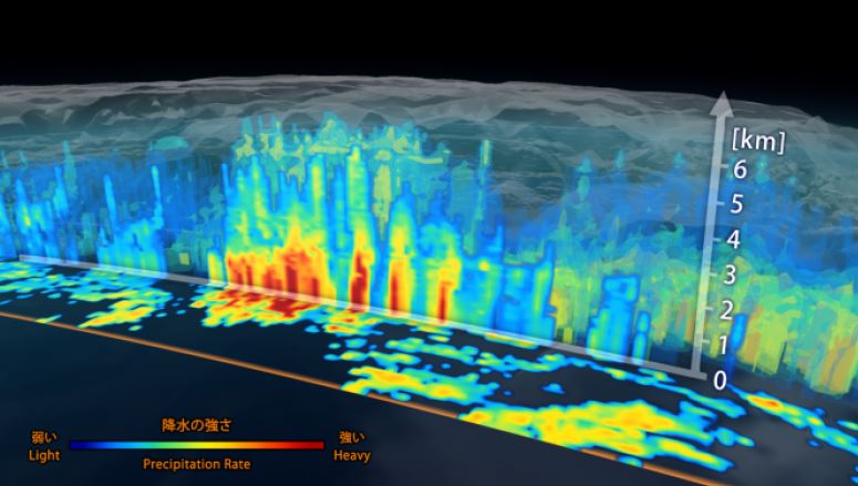
A 3D view inside the cyclone provided by JAXA’s DPR aboard the satellite. The vertical cross-section 7 miles high shows rain rates: red areas indicate heavy rainfall while yellow and blue indicate less intense rain. Image courtesy JAXA/NASA.
They include JAXA’s Dual-frequency precipitation radar (DPR), which provides three-dimensional imagery, and NASA’s GPM Microwave Imager (GMI), which observes a broad swath of precipitation.
GPM project scientist Gail Skofronick-Jackson, at NASA’s Goddard Spaceflight Center in Greenbelt, Md., said it was exciting to see the high-quality GPM data for the first time.
“I knew we had entered a new era in measuring precipitation from space,” she said in a NASA statement today. “We now can measure global precipitation of all types, from light drizzle to heavy downpours to falling snow.”
Scientists use the data to calculate the rain rate, which is how much rain or snow falls to Earth. NASA said rain rate is one of GPM’s essential measurements for understanding where water is on Earth and where it’s going.
“All this new information comes together to help us better understand how fresh water moves through Earth’s system and contributes to things like floods and droughts,” Skofronick-Jackson said.
This comments section is a public community forum for the purpose of free expression. Although Big Island Now encourages respectful communication only, some content may be considered offensive. Please view at your own discretion. View Comments