In its 11 a.m. update, the National Weather Service reduced the amount of rain predicted for the Big Island from Flossie to two to four inches, with the possibility of up to six inches in some areas.
The service previously had forecast six to 10 inches from the storm.
***Updated at 9:47 a.m.***
It appears Flossie has developed a bit of a split personality, Hawaii County’s Civil Defense chief said this morning.
“With the latest forecast we’re showing that the system has almost developed two separate cells,” Darryl Oliveira said in an interview with Big Island Now’s Josh Pacheco.
“The first cell is tracking along the northern portion of the island still presenting with high winds along with the rains and high surf and surge potential,” he said.
“The second cell that is further south is posing a threat to the southern portion of the island with primarily heavy rains,” Oliveira said.
He said that the National Weather Service is forecasting that the southern half of the island may not necessarily see the high winds but will definitely experience heavy rains.
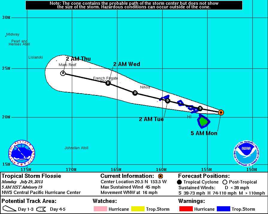
As indicated in this National Weather Service graphic, the portion of Flossie with heavier winds took a slightly northerly turn overnight, taking it from a direct path toward the Big Island more toward its northern shore, and the western portion of the state.
“So presently we are preparing for flooding conditions islandwide and high winds and surf issues along the northern coastline,” he said.
Oliveira said the Big Island should start seeing the effects of the storm around mid-morning.
Tropical Storm Flossie had moved to within 90 miles northeast of Hilo at 8 a.m. this morning.
Although 12 hours ago Flossie was packing 60 mph winds, the 8 a.m. report from the Central Pacific Hurricane Center said the maximum sustained winds were down to 40 mph. However, those winds were extending outward up to 90 miles, the center said.
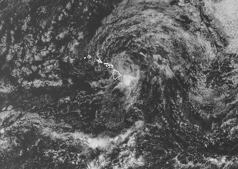
This view of Flossie’s splitting cells taken from a satellite covering the Central Pacific show the broad area of moisture heading toward the Big Island. NWS image.
Those weakening conditions mean that Flossie could soon lose its tropical storm status, which is assigned to storms with winds of at least 39 mph.
But the storm is still packing plenty of moisture, the center said, with rainfall amounts of six to 10 inches forecast for the Big Island, with lesser amounts for the western part of the state.
Also, “dangerously high” levels of surf were hammering east-facing shores of the Big Island this morning and those swells are expected to spread to the rest of the islands today and into Tuesday, the center said.
This comments section is a public community forum for the purpose of free expression. Although Big Island Now encourages respectful communication only, some content may be considered offensive. Please view at your own discretion. View Comments