Tremors continue to shake the Solomon Islands in the southwest Pacific, including a 7.0-magnitude quake that hit the archipelago at 5:26 a.m. today Hawaii time.
None, including the magnitude 8.0 earthquake that rocked the area on Tuesday, have generated a wide-ranging tsunami.
However, since that earthquake three days ago the Solomons have been hit by more than 100 aftershocks of 5.0 or greater, including six of magnitude 6.0 or more. Two have been of magnitude 7.0.
The Associated Press is reporting that aftershocks are hampering efforts to give aid to those affected by a tsunami five feet in height that swept the shores of Santa Cruz Island. Nine have been confirmed dead as a result of the waves.
ARTICLE CONTINUES BELOW AD
ARTICLE CONTINUES BELOW AD
A plane carrying Prime Minister Gordon Darcy Lilo as well as food, water and medical supplies had to turn back when the temblor hit today (Friday in the Solomon Islands), AP said.
Paul Okubo, a seismologist at Hawaiian Volcano Observatory on the Big Island, said multiple aftershocks are expected after such a powerful earthquake.
“It’s the fault system adjusting to changes from the earthquake,” Okubo said.
While residents here are familiar with earthquakes caused primarily by the settling of the isle’s five volcanoes – the Big Island experienced five quakes of magnitude 2.0 or greater just on Wednesday – Okubo said the activity in the Solomon Islands is providing a valuable perspective for people here and elsewhere.
ARTICLE CONTINUES BELOW AD
For comparison, the earthquake that occurred off the North Kona coast of the Big Island on Oct. 15, 2006 had a magnitude of 6.7.
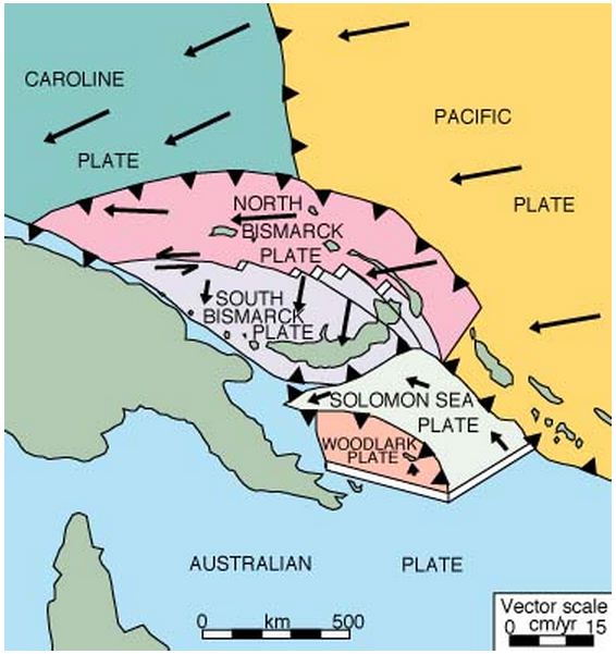
There are a variety of geologic forces at play in the area around the Solomon Islands, shown in light green in the center and center-right in this image from Oregon State University. Papua New Guinea is at center left.
That quake, which was followed by a magnitude-6.0 aftershock, was felt across the state and caused more than $100 million in damage, prompting a disaster declaration by then-Gov. Linda Lingle.
There are significant geologic differences between the Big Island, which sits on a “hot spot” in the middle of the Pacific Plate, and the Solomons, which are located along the edges of several tectonic plates.
The geology in the area of the Solomon Islands and neighboring Papua New Guinea is complex, described by researchers as “one of the … most actively deforming areas on Earth.” It consists of a handful of microplates in tectonic upheaval, involving both subduction zones as well as spreading centers, areas where plates are moving apart.
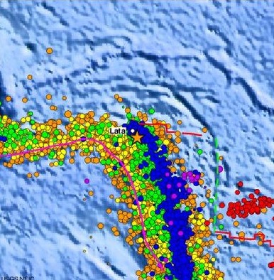
This USGS image shows seismic activity in the Santa Cruz Islands since 1990.
ARTICLE CONTINUES BELOW AD
The former include the Solomon Sea Plate which is diving at a rapid rate beneath the South Bismarck Plate to the northwest and the Pacific Plate to the northeast.
The result is nearly constant seismic unrest as well as volcanism which has helped create the Santa Cruz Islands, the part of the Solomons where most of the recent seismic activity has occurred, and Kavachi, one of the world’s most active submarine volcanoes.
This comments section is a public community forum for the purpose of free expression. Although Big Island Now encourages respectful communication only, some content may be considered offensive. Please view at your own discretion. View Comments